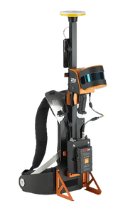
ZEB Horizon RT
GeoSLAMPlease Call for a Quote and to Setup a Free Demo at (724) 266-1600 or PLI@Laserinst.com
GeoSLAM ZEB Horizon RT
Capture, Process & Understand the World Around You
The GeoSLAM ZEB Horizon RT offers the benefits of the traditional ZEB Horizon but with a different datalogger to enable real-time processing!
GeoSLAM ZEB Horizon RT Datasheet (CLICK HERE!)
Add Georeferencing Capability to the ZEB Horizon with the ZEB Locate! (CLICK HERE!)
- Lightweight and rugged, simple to use, fast to capture and easy to process
- Powerful SLAM technology that allows it to be used even in remote areas with poor GPS, such as underground or in forest environments
- A range of mounting options, including UAV compatibility to let you go further than ever
- A collection rate of 300,000 points per second, accuracy of 1-3cm and range of 100m
Optional ZEB Horizon RT Accessories:
- ZEB Discovery: LiDAR and high-resolution imagery
- ZEB Locate: Connect your point cloud to the real world, without the need for external control points
- GeoSLAM Cradle: Allows you to mount your ZEB for vertical deployment
- Carbon Fiber Pole: This allows you to mount your ZEB for mapping at height
- GeoSLAM Guard: Provides increased protection for vertical deployment
- UAV Mount: Allows the ZEB Horizon to be mounted to a UAV
- Car Mount: Allows for vehicle-mounted data collection
- ZEB Vision: Better than ever colorization with 4K panoramic resolution
- ZEB Pano: Add 360 panoramic photography to your point clouds
Ask About GeoSLAM Care Support (CLICK HERE!)
What You'll Love About GeoSLAM
GeoSLAM ZEB FAMILY Brochure (CLICK HERE!)
-
More Competitive: Being able to offer rapid results to clients makes everything you do more competitive and gives you the potential to offer services to a wider degree
-
Ease of Use: GeoSLAM’s scanners can be used by anyone, so you don’t need to be a seasoned expert to create accurate 3D models
-
Go Anywhere: GeoSLAM can be used anywhere, from the tightest spaces to remote spots, without the need for GPS
-
Speed: If you can scan faster, you can work faster, maximizing your time and allowing you to determine layouts, calculate room size and produce floor plans within minutes
-
Continuous Data Collection: GeoSLAM’s scanners allow for continuous data processing, which means you can see individual measurements, including topographical details alongside key features
- Accuracy: From design, to construction and maintenance, GeoSLAM’s scanners can be used to quickly and accurately scan and collect data at each stage of a building’s development
- Create and Manage a Digital Twin: For true project collaboration, effortlessly and accurately create a digital twin of any built environment, both indoor and outdoor


