X12 3D Scanner
TrimblePlease Call for a Quote and to Setup a Free Demo at (724) 266-1600 or PLI@Laserinst.com

Trimble X12 3D Laser Scanning System:
Datasheet | Applications | Comparison
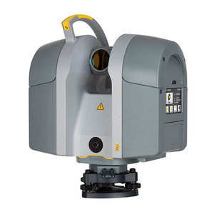
The Trimble X12 is an accessible, high-end 3D laser scanning system with superior speed, accuracy, range and incredible image clarity. Its simple field workflows are suitable for all users, and Trimble Perspective software allows you to auto-register, refine and export scan data in the field.
Key Features:
- Scan up to 2.2 million, ultra-accurate points per second and view with vivid panoramic images
- Effective working range of up to 250m
- Range accuracy of ≤ 1mm + 10ppm/m
- Range resolution of 0.1mm
- Simple field workflows suitable for all users
- Trimble Perspective software to auto-register, refine and export scan data in the field
- Clearly view and validate scans and images on the fly
- Robust IP54 rating and 2-year standard warranty
Applications:
- General & Topographic Surveys: Quickly capture features for land title surveys, buildings, roads, intersections, site improvements, encroaching elements and complex structures
- Document and highlight features or items of interest using annotations.
- Assign labels to each scan to create logical scan groups and annotations with pictures while scanning the next station.
- Use auto-classification tools to extract data corresponding to the ground, buildings, powerlines, signs, vegetations and more.
- Create as-builts of road corridors, intersections, roadway surfaces, lane stripping, flow lines, manholes, right of ways, overhead power lines and other features.
- Industrial Survey: Create accurate as-builts of complex industrial facilities for modeling and revamp designs.
- Take high-resolution area scans for more detail on points of interest and safely capture inaccessible areas from a distance.
- View details of existing conditions for critical decisions.
- Enhance in-field documentation with annotations and pictures of tie-in locations inside Trimble Perspective.
- Georeference scans to plant coordinate systems using Trimble RealWorks target-based registration and survey control for export-to-plant design software to do piping layouts, check fabrication spools and detect interferences with CAD models.
- Civil Infrastructure: Create as-built documentation for drawings or models of bridges, tunnels, dams and more with a range that allows for operation from a safe distance.
- Incorporate scan information in clearance calculations, modeling, inspections, renovations and expansion work
- Leverage high-speed data capture and quickly capture area scans to reduce downtime for critical infrastructure projects
- Benefit from unmatched HDR image quality for visual inspection and sharing of information.
- Register in the field to verify scan data is complete before importing to Trimble Business Center or Trimble RealWorks at the office.
- Digital Twin: Effectively create as-builts for scan-to-BIM and renovations, providing clarity for adaptive reuse, building extensions and inspection of facades and elevations.
- Optimize commercial building design accessibility.
- Produce perfectly colorized point clouds using parallax free images and clearly view the project off-site.
- Register in the field to eliminate the risk of return visits, especially where access permits are difficult to obtain.
- Transfer data to Trimble Business Center, Trimble RealWorks or other CAD software for final analysis and design.
- Tank Calibration & Inspection: Quickly and safely produce accurate data for precise storage tank analysis, saving time and money.
- Reduce downtime with high-speed scanning backed by an IP54 rating with a two-year warranty for reliable operation in extreme conditions.
- Efficiently capture precise details of storage tanks and surrounding containment areas to document verticality, roundness and integrity.
- Easily capture and verify data in the field before importing into Trimble RealWorks Storage Tank module.
- Calculate tank volume filling tables and secondary containment volumes, perform deformation analysis for tank repairs and create reports meeting API 653 standards.
- Shipbuilding Surveys: Create as-builts for new construction and renovation.
- Effectively operate in the confined spaces of ships with the best minimum scan range in the industry of 0.3 meters.
- Capture data of the hull, on deck or in holds with long range, high resolution scans.
- Quickly scan ballast tanks in preparation for water treatment systems for retrofit to comply with IMO mandates.
- Obtain the level of detail needed by the naval architect before the ship leaves port.
- Forensics: Capture precise information at crime scenes and vehicular accidents while minimizing road closures, even in extreme weather.
- Add annotations with pictures to points of interest and take measurements in the field.
- Generate unmatched, high-resolution image quality, even at night, with the LED spotlights.
- Register in the field to verify complete data capture before leaving the scene.
- Export data to Trimble Forensics Reveal software for creation of 2D/3D diagrams and animations for investigation and reconstruction.
- Cultural Heritage: Inspect and monitor surface deterioration, as well as high-resolution imagery for documentation, analysis and restoration.
- Retain important details with high-resolution area scans on points of interest and safely capture inaccessible areas from a distance.
- Digitally preserve fragile artifacts for re-creation.
- Document and share the site with high-resolution panoramas and clear color imagery.
- Add annotations in the field with images to highlight areas of interest back in the office.
- Check data quality before leaving the site to eliminate cost and time-consuming field revisits.


