Trimble R2 GNSS Receiver
TrimblePlease Call for a Quote and to Setup a Free Demo at (724) 266-1600 or PLI@Laserinst.com

Trimble R2 GNSS Receiver: Datasheet
The Trimble R2 is a compact, durable GNSS receiver that provides an easy-to-use solution for GIS professionals who need to collect highly accurate data in applications ranging from mapping and locating underground infrastructure, such as pipes and cables, to inspecting storm water drains, and much more.
Capable of delivering between submeter and centimeter positioning accuracy in real-time to any mobile device via a wireless Bluetooth® connection, the R2 receiver gives you total flexibility to choose a solution based on the accuracy and GNSS performance level that suits your application, letting you work the way you want.
Versatile and reliable, the Trimble R2 is the answer to keep you working productively, no matter what your workflow requirements are.
High Accuracy for your GIS Applications
- Capable of delivering submeter to centimeter level positioning accuracy in real-time to suit any GIS field data collection application.
- Achieve higher accuracy in real-time using correction sources from SBAS and VRS networks to Trimble RTX™ correction services, delivered by either satellite or Internet.
- Achieve higher accuracy in real-time using correction sources from SBAS and VRS networks to Trimble RTX™ correction services*, delivered by either satellite or Internet that includes CenterPoint® RTX (4 cm), FieldPoint RTX™ (10 cm), RangePoint™ RTX (30 cm), ViewPoint RTX™ (50 cm) correction services.
- Supports multiple satellite constellations and augmentation systems to provide maximum accuracy and positioning performance.
Flexible Solution
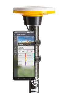
- Able to be paired with any mobile device on a variety of operating systems and platforms, from a Trimble handheld to a modern smartphone or tablet.
- You can select the accuracy and GNSS performance level appropriate for your application.
- Capable of being operated either mounted on a pole, on a backpack or on a vehicle.
- Integrates with Trimble Mapping & GIS software such as Trimble TerraFlex™ to enable data to be easily collected, communicated and processed, providing you with high-quality deliverables for your organization.
Simple, Rugged System
- One-button start up and compact, streamlined design enables a quick setup.
- Built to withstand tough conditions meeting military specifications MIL-810G for ruggedness and an IP65 rating.
Key Features
- A professional solution for geospatial applications ranging from sub-meter to centimeter accuracies to support any GIS or survey-grade workflow
- Easily collect data by pairing with devices such as smartphones, tablets or Trimble handhelds using Trimble Survey and GIS software
- Fast to setup, easy to use, keeping you productive and focused at your task at hand
- Supports multiple satellite constellations and correction sources for accurate data at any location
- Trimble Maxwell 6 chip with 220 channels and leading GNSS technology maximizes data quality
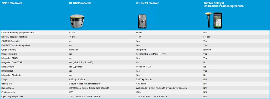
Comparison Chart

For more information, be sure to check out the FAQ and Datasheet!
For available financing options or if you would like to discuss how the R10 could help your business, contact your local PLI office today!


