Posted by Precision Laser & Instrument, Inc. on 29th Apr 2025
Trimble Access v2025.10 is Now Available!
"#TrimbleAccess v2025.10 is Now Available & Packed w/ Powerful Enhancements Designed to Streamline Your #Surveying Workflow!"
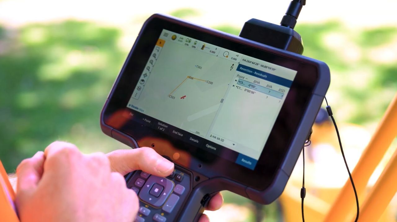
"1) Auto-Resection: #Trimble Access Now Automatically Calculates Positions & Names "Undefined" Points, Speeding Up Setup Time Significantly. This is a Game-Changer for Underground & #Construction #Surveyors, Allowing You to Focus on the Task at Hand w/o Memorizing Control Point Names. Easily Cycle Between Solutions & Review Them on the Map for Precise #Positioning.
2) Measure Line: Easily Draw Lines Between Points, Using a Combination of Newly Measured & Existing Points, Creating Lines w/ a Single Set of Attributes. Edit Lines by Adding or Removing Points. This Enhancement Ensures Your Line Features are Accurate & Easy to Manage.
3) Prism Icons: The Status Bar Now Displays the Prism Type When Using a #TotalStation, Helping You Avoid Setout Errors & Ensuring Accurate Surveying.
4) Shapefile Export: Export Linework, Feature-Coded Linework & Attributes Seamlessly. This Enhancement Ensures Your Data is Comprehensive & Ready for Further Analysis.
5) Cloud Integration: View Your Trimble Access Jobs in a Map View, Create Jobs w/ the Field Data Extension & Push Important Design Files to All Project Users. Share Site Calibrations & Feature Code Libraries Effortlessly, Ensuring Everyone is on the Same Page.
6) Roads: Features - Navigate Complex Linework w/ Ease Using the Nearest String Stakeout Method. Perfect for Staking Arcs & Curves, This Feature Enhances Your Road-Related Surveys."
#PLI #Geospatial #GeospatialLife #GeospatialData #GeospatialTech #GeospatialTechnology #GeospatialSolutions #GeospatialAnalysis #SurveyLife #Surveyor #Surveyor #LandSurvey #LandSurveying #LandSurveyor #LandSurveyor #SurveyingSoftware #SurveyingTechnology #LicensedSurveyor #CertifiedSurveyor #EngineeringLife #ConstructionLife #NSPS #PLS