Posted by Precision Laser & Instrument, Inc. on 11th Jan 2021
News
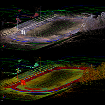
Checkout these cool #TrimbleX7 scans from a project being done on a local high school's sports field!Learn More About the Power of #3DScanning & Schedule a Demo!https://www.laserinst.com/survey/laser-
…
Posted by Precision Laser & Instrument, Inc. on 8th Jan 2021
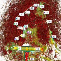
Tunnel Shotcrete Verification using Scan Data!
"This sample dataset – utilizing #3dlaserscanning data from a #Trimble #TX8 – demonstrates how to perform #tunnelconstruction control for #excavation, #shotcrete, and final lining in a NATM/SEM tunnel
…
Posted by Precision Laser & Instrument, Inc. on 9th Dec 2020
Trimble X7 Dam Project - Scanned, Colorized, Refined, Georeferenced & Exported in the Field!
"The #pointcloud data in this project – from a remote forest area in Japan – was collected using the #TrimbleX7 and was colorized, refined, geo-referenced and exported directly in the field. Read the
…
Posted by Precision Laser & Instrument, Inc. on 3rd Dec 2020
Checkout This Virtual Surveying Dataset Using 3D Scans!
"Checkout this virtual survey of an intersection and see how #Trimble Business Center (#TBC) processes and analyzes #3DScanning Data by downloading the following #dataset."#VirtualSurveying Dataset:&n
…
Posted by Precision Laser & Instrument, Inc. on 3rd Nov 2020
How-To Georeference Scans with the Trimble X7!
Checkout this helpful #TBC How-To From #Trimble on #TrimbleX7 #Georeferencing!Watch: https://bit.ly/387QG7PSchedule a Local Demo!https://www.laserinst.com/trimble-x7724-266-1600 | PLI@laseri
…
Posted by Precision Laser & Instrument, Inc. on 12th Oct 2020
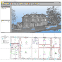
Trimble X7 Floor Plan Study - 110 Scans in a Single Day!
"All 110 #scans in this sample dataset of an old building were collected in a single day with the #TrimbleX7 #3DLaserScanner. A #floorplan was then created applying the automatic classification functi
…


