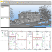
Posted by Precision Laser & Instrument, Inc. on 24th Aug 2023
News
Sample #Dataset: "#TrimbleMX50 #RuralRoad Project!" View: https://bit.ly/3YRBFQcLearn More & Schedule a Local Demo! https://bit.ly/3YRBFQc #PLI #Trimble #Geospatial #GeospatialLife #Geos
…
Posted by Precision Laser & Instrument, Inc. on 2nd Sep 2022
Trimble X12 Dataset: Urban ATC Tower
"Checkout an urban ATC tower - at the site of the former Stapleton International Airport in Denver - scanned with a #TrimbleX12 in high x2/speed scans!" Dataset: https://bit.ly/3TChti3 #PLI #Trim
…
Posted by Precision Laser & Instrument, Inc. on 22nd Apr 2021
Trimble SX12 Simple Survey Dataset!
"This #Trimble Business Center project highlights the capabilities of the #TrimbleSX12 #3DScanning #TotalStation. It was captured in just over an hour, with two instrument stations setup via rese
…
Posted by Precision Laser & Instrument, Inc. on 3rd Dec 2020
Checkout This Virtual Surveying Dataset Using 3D Scans!
"Checkout this virtual survey of an intersection and see how #Trimble Business Center (#TBC) processes and analyzes #3DScanning Data by downloading the following #dataset."#VirtualSurveying Dataset:&n
…
Posted by Precision Laser & Instrument, Inc. on 12th Oct 2020
Trimble X7 Floor Plan Study - 110 Scans in a Single Day!
"All 110 #scans in this sample dataset of an old building were collected in a single day with the #TrimbleX7 #3DLaserScanner. A #floorplan was then created applying the automatic classification functi
…
Posted by Precision Laser & Instrument, Inc. on 12th Aug 2020
Trimble Offers Aggregate Datasets to Help You Learn & Create More Accurate & Efficient Deliverables!
Did You Know? "Trimble now offers aggregated #datasets for users to learn more about #Trimble solutions, including how to create more accurate and efficient scans and workflows!" View & Downl
…


