


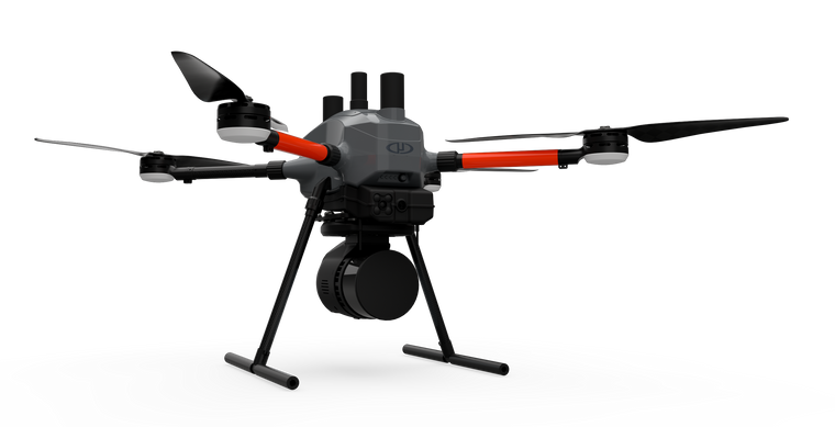
EasyOne LiDAR UHR Lite
GeoCue MicrodronesPlease Call for a Quote and to Setup a Free Demo at (724) 266-1600 or PLI@Laserinst.com
(No reviews yet)

Write a Review
GeoCue Microdrones
EasyOne LiDAR UHR Lite
GeoCue Microdrones EasyOne LiDAR UHR Lite
Learn More | Video
This is GeoCue Microdrones' best LiDAR drone surveying equipment ever. Built upon our 4th-gen drone technology, all EasyOne systems are more compact, more optimized, lighter, safer and more efficient. This system delivers integration unmatched in the drone surveying industry, making it easier than ever for you to plan, fly, collect, process and visualize your geospatial data projects.
EasyOne features a significantly smaller operational form factor with the same payload capacity of the md4-1000 platform. In addition to a smaller operational form factor, the EasyOne packs down even smaller, fitting the drone, remote, charger, two batteries and the payload into a protective storage case that’s small and light enough to bring anywhere.
THE COMPLETE PACKAGE FROM ONE COMPANY: MICRODRONES.
Microdrones technology, firmware, software and workflow developed and refined since 2006 is used with the new physical hardware to provide:
- Hesai Pandar XT-16 LiDAR Sensor
- New autopilot integrated into a single board— this means less cabling, less weight, more compactness and less risk of connection-related failures and better electromagnetic compatibility
- mdCockpit software ecosystem for mission planning and control directly integrated into the RC
- Microdrones completed all necessary testing to make md4-EasyOne a "Remote Identification Unmanned Aircraft" following FAA 14 CFR Part 89
- Payload connection/communication quick connect
- Real time terrain follow and collision awareness
- NDAA compliant RC controller options
EASY END-TO-END WORKFLOW:
- PLAN
- Simple mission planning using mdCockpit
- User selects flying height, drone speed and LiDAR strip overlap
- FLY
- Fully automated mission execution, realtime monitoring, and flight control using mdCockpit
- PROCESS
- Thorough georeferencing data processing using the Applanix APX-15 UAV DG and LP360 Drone Software
- Automated final pointcloud processing using LP360 Drone processing software
- VISUALIZE
- Final pointcloud in standard ASPRS LAS format, View your deliverable in LP360 Drone software, or export to use within any GIS or CAD software environment that you currently use.
APPLICATIONS:
- Aerial Mapping / Surveying
- Construction
- Mining
- Volumetrics
- Precision Agriculture
- Digital Twins
- Defense


